Quarry & Western States Loop Trail
This loop affords regular users of the Quarry Trail an alternate route rather than the normal out and back.
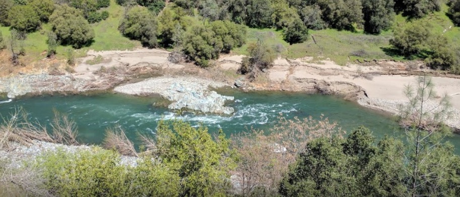
The Quarry Trail portion of this loop follows the wide, level bed of the Mountain Quarries RR. It affords nice views of the Middle Fork American River. The two sections of the Western States Trail (WST) cut through the dense foothill woodlands above the river. This loop affords regular users of the Quarry Trail an alternate route rather than the normal out and back. It highlights a small portion of the WST while skirting the quarry operation. The loop goes from river to canyon rim and back. Trails Included: Quarry Trail, Western States Trail-Tevis (portion), Western States Trail (portion), Shortcut Trail 1 (optional).
- Distance 6.3 miles
- Approx length of time 3 hours (hiking)
- Difficulty Moderate to Difficult
- Website Quarry & Western States Loop Trail
- Best Feature Beautiful views of the Middle Fork American River
- Hiking
- Biking
- Equestrian

Trailhead is 2 miles south of ASRA Park Headquarters. Take Hwy 49 south from Auburn; turn right across the American River towards Cool. Turn left on a small dirt road ¼ mile south of the river crossing. Trailhead is beyond the parking area at green gate (#151).
ALSO CHECK OUT:
-

H2O Adventures
Lotus, CA6400 CA-49, Lotus, CA 95651From Whitewater beginner to adventure seeker, we’ve got the trip for you.
-

Peninsula Campground
Pilot Hill, CARattlesnake Bar Road, Pilot Hill, CA 95664The campground has 100 family campsites that will accommodate trailers up to 18 feet in length and motor homes up to 24 feet.
-
Miner’s Camp
Foresthill, CA24381 Foresthill Road, Foresthill, CA, USAOwn your piece of Gold Rush History and close by is the Auburn State Recreation Area offering many outdoor adventures.


