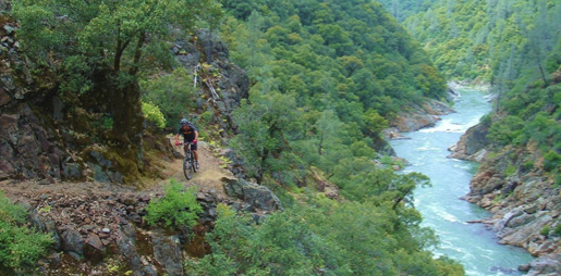
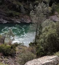
Green Valley Trail
From Interstate 80, take the Foresthill exit to Foresthill Road and proceed 15.5 miles to the Foresthill Ranger Station
From Interstate 80, take the Foresthill exit to Foresthill Road and proceed 15.5 miles to the Foresthill Ranger Station. Continue 10 more miles to Sugar Pine Road (Forest Road 10). Follow it for 5 miles until you cross Sugar Pine Dam. One mile beyond the dam, turn right on to Elliot Ranch Road, which is the dirt road just past the paved road to the campground. Travel 3 miles to the signed trailhead and make a left. NOTE: The road is rocky and a high clearance vehicle is advised.
- Distance 2.62 miles each way
- Difficulty Difficult
- Website Green Valley Trail
- Best Feature Good fishing is available at times, and river access with limited camping is possible along the trail
- Hiking
- Biking
- Fishing

From Interstate 80, take the Foresthill exit to Foresthill Road and proceed 15.5 miles to the Foresthill Ranger Station. continue 10 more miles to Sugar Pine Road (Forest Road 10). Follow it for 5 miles until you cross Sugar Pine Dam. One mile beyond the dam, turn right onto Elliot Ranch Road, which is the dirt road just past the paved road to the campground. Travel 3 miles to the signed trailhead and make a left. NOTE: The road is rocky and a high clearance vehicle is advised.
ALSO CHECK OUT:
-
Confluence Interpretive Trail
Auburn, CAHighway 49 S, across from ASRA Park HQ, Auburn, CA 95603The confluence of the North and Middle Forks American River affords a marvelous opportunity to view the natural wonders of this river canyon environment and to glimpse the past via the remains of its historic bridges.
-
Upper Stagecoach Trail
Foresthill, CAHighway 49 S, Auburn, CA 95603While not as wide, level or well graded as Stagecoach Trail, it provides another perspective on the canyon, and has some shade.
-
Tahoe Donner Equestrian Center
Truckee, CA15275 Alder Creek Road, Truckee, CA 96161Offers trail rides, pony rides, horse boarding, riding lessons, tack shop, Horsemanship Camps and BBQ Rides.


