Mosquito Ridge Trail
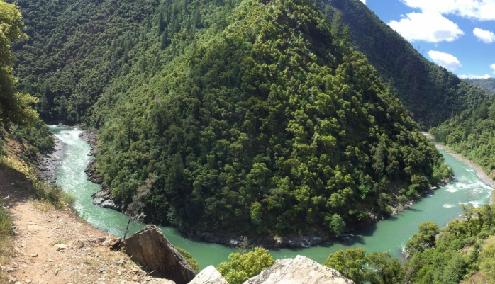
This trail is very steep in places with many switchbacks, as it winds its way down to the Middle Fork of the American River.
This trail is very steep in places with many switchbacks, as it winds its way down to the Middle Fork of the American River. About halfway down across the canyon, there is a pretty cascade of water coming down the canyon wall. The river has good fishing at times, and there are adequate campsites on the large gravel bars along the river. Fire permits are required for campfires, backpacking stoves, BBQs and lanterns. Because this is a southerly exposure, the trail can be hot during a warm day, and is a pleasant hike during the spring and fall. Poison Oak is present, especially at the beginning of the trail.
- Distance 1 mile each way
- Difficulty Difficult
- Website Mosquito Ridge Trail
- Best Feature About halfway down across the canyon, there is a pretty cascade of water coming down the canyon wall
- Hiking
- Biking
- Equestrian

From Interstate 80, take the Foresthill exit to Foresthill Road and proceed 15.5 miles to the Foresthill Ranger Station. Continue 1.2 miles and turn right onto Mosquito Ridge Road. Travel approximately 12.4 miles to the trail sign on the right. Park on the left side of the road in the turnout and then cross the road to begin the trail.
ALSO CHECK OUT:
-
Waterman’s Landing
Carnelian Bay, CA5166 North Lake Boulevard, Carnelian Bay, CA 96140Waterman’s Landing is Tahoe’s premiere source for paddle sports purchase, boards, paddles, paddle sports accessories and paddle sports rental on Lake Tahoe.
-

North Tahoe Watersports
Tahoe Vista, CA8400 North Lake Boulevard, Kings Beach, CA 96143The company offers a full selection of recreational water sports activities, including parasailing flights and personal watercraft rentals.
-
Donner Summit
Donner Summit, CA19455 Bunny Hill Drive, Soda Springs, CA 95728Donner Summit boasts five alpine ski resorts, miles of cross country skiing, and numerous snow play areas.

