

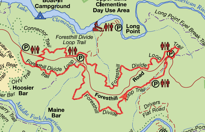
Foresthill Divide Loop Trail
This loop offers some beautiful views of Lake Clementine and both the North Fork and Middle Fork American Rivers.
This loop offers some beautiful views of Lake Clementine and both the North Fork and Middle Fork American Rivers. Straddling the Foresthill Divide at elevations ranging from 1600 to 1900 feet, it provides a diversity of flora as it passes through all four American River Canyon eco-systems: yellow pine forest, foothill woodland, riparian woodland, and chaparral. It also passes through open grasslands that are abundant with wildflowers in the spring.
- Distance Distance: 8.2 miles Shorter loops are also possible. Add 1 mile from Trailhead West.
- Approx length of time 4.1 hours (hiking)
- Difficulty Easy to Moderate
- Website Foresthill Divide Loop Trail
- Best Feature Passes by the old rock foundation of the Grizzly Bear House
- Hiking
- Biking
- Equestrian

Trailhead West is on Foresthill Rd, 3½ miles east of Foresthill Bridge, at a large parking area on the right (known locally as the Grizzly Bear House turnout).
Trailhead East is on Foresthill Rd, 7 miles east of Foresthill Bridge (0.2 miles past Drivers Flat Road) at a large parking area on the left. Both trailheads have a port-a-potty.
ALSO CHECK OUT:
-
Regional Park
Auburn, CA3770 Richardson Drive, Auburn, CA 95603A year-round creek meanders through the north end of the park, and playground and picnic areas are nested in shaded areas.
-
Auburn State Recreation Area
Auburn, CAHighway 49 S @ Old Foresthill Road, Auburn, CA 95603In this beautiful setting next to the Middle Fork of the American River, you have river access and you can participate in boating, fishing, camping, hiking, mountain biking, gold panning, equestrian/horseback riding trails, and off-highway motorcycle riding.
-

Patton Landing – Watermans Landing
Carnelian Bay, CA5166 North Lake Boulevard, Carnelian Bay, CA 96140Stand-up paddleboard and kayak rentals are conveniently available.


