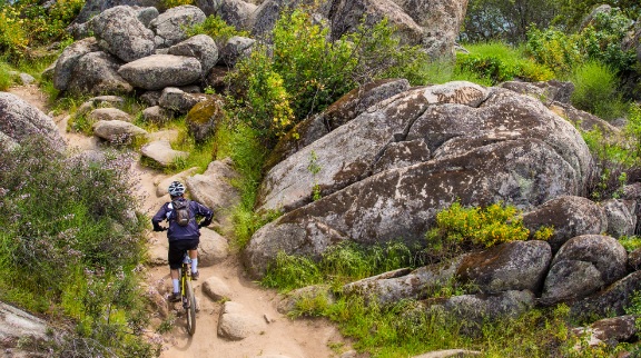
Western States Trail – Railroad Bed Section
This short section of the Western States Trail offers an easy outing with ever changing views of the American River.
This short section of the Western States Trail offers an easy outing with ever changing views of the American River. The trail follows the old Mt Quarries RR roadbed for most of its route. Thus it is fairly wide and level in most places. Users pass several reminders of the railroad along the way. The trail remains in sight of the river through much of its length. Several small unofficial trails provide access down to the river and its many gravel bars that serve as swimming spots.
- Distance 2 miles
- Approx length of time 1 hour each way (hiking)
- Difficulty Easy to moderate
- Best Feature Views of the American River
- Hiking
- Biking
- Equestrian

Trailhead East (Confluence area by Hwy 49 Bridge): Trailhead is on Hwy 49, 1¾ miles south of ASRA Park Headquarters. Take Hwy 49 south from Auburn towards Placerville. After crossing the American River, park on right off the highway. Walk to trailhead through the green gate (#150).
Trailhead West: (Robie Point Trailhead): Trailhead is accessed from parking area on Hwy 49, southbound from Auburn ½ mile (on the right) or northbound from ASRA Park Headquarters ¼ mile (on the left). Caution: cars coming downhill are hard to see. From the parking area behind the gate (#130), walk ½ mile of Robie Pt Trail. The trailhead is a narrow trail on the left marked with a metal “Trail” or WST sign.
ALSO CHECK OUT:
-
Tahoe Sailing Charters
Tahoe City, CA700 North Lake Boulevard, Tahoe City, CA 96145They are committed to providing a fun, safe experience for all who wish to enjoy the spectacular lake and mountain views.
-

North Fork of the Middle Fork Trail
Foresthill, CAMosquito Ridge Road, Foresthill, CA 95631Although it is primarily used by people placer mining along the river, other hikers are drawn to this area due to its easy grade, scenic beauty, and year round accessibility.
-

Whitewater Excitement
Lotus, CA6580 Highway 49 Lotus, CA 95651THE THRILL … of the river is calling. For our family-run operation, giving our guests the best California white water rafting experience is a point of pride. At Whitewater Excitement, all hands are on deck to provide the best service, the highest safety standards, the most fun, and the wildest adventure.


