Western States Trail – Railroad Bed Section
This short section of the Western States Trail offers an easy outing with ever changing views of the American River.
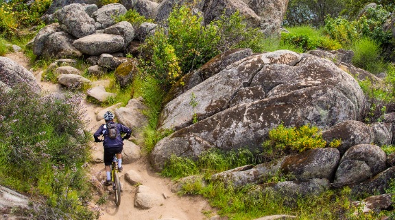
This short section of the Western States Trail offers an easy outing with ever changing views of the American River. The trail follows the old Mt Quarries RR roadbed for most of its route. Thus it is fairly wide and level in most places. Users pass several reminders of the railroad along the way. The trail remains in sight of the river through much of its length. Several small unofficial trails provide access down to the river and its many gravel bars that serve as swimming spots.
- Distance 2 miles
- Approx length of time 1 hour each way (hiking)
- Difficulty Easy to moderate
- Best Feature Views of the American River
- Hiking
- Biking
- Equestrian

Trailhead East (Confluence area by Hwy 49 Bridge): Trailhead is on Hwy 49, 1¾ miles south of ASRA Park Headquarters. Take Hwy 49 south from Auburn towards Placerville. After crossing the American River, park on right off the highway. Walk to trailhead through the green gate (#150).
Trailhead West: (Robie Point Trailhead): Trailhead is accessed from parking area on Hwy 49, southbound from Auburn ½ mile (on the right) or northbound from ASRA Park Headquarters ¼ mile (on the left). Caution: cars coming downhill are hard to see. From the parking area behind the gate (#130), walk ½ mile of Robie Pt Trail. The trailhead is a narrow trail on the left marked with a metal “Trail” or WST sign.
ALSO CHECK OUT:
-
Lake Forest Boat Ramp & Campground
Tahoe City, CA2500 Lake Forest Road, Tahoe City, CA 96145Campsites are available on a first-come first-serve basis and located just a few blocks away from the Lake Forest Beach.
-

Soda Springs
Norden, CA10244 Soda Springs Road, Soda Springs, CA 95728Secluded in the picturesque pines and conveniently located directly of off interstate 80, the mountain’s welcoming resort spirit and relaxed atmosphere is perfect for families new to snow.
-

Geocaching in Lake Tahoe
Olympic Valley, CAHigh Camp, Olympic Valley, CA 96146Geocachers can ride Lake Tahoe’s scenic Aerial Tram up to High Camp, el. 8200 feet, to find 10 caches hidden among the mountain’s peaks using GPS coordinates.


