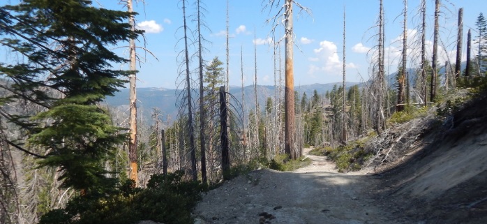
Sailor Flat Trail
The first 1½ miles of the trail follows an old mining road and is relatively easy. The trail then becomes steeper, with many switchbacks as you drop down to the North Fork of the American River.
The first 1½ miles of the trail follows an old mining road and is relatively easy. The remains of an old gold stamp mill stands near the trailhead. The trail then becomes steeper, with many switchbacks as you drop down to the North Fork of the American River. Good fishing is available at times and limited camping is available along the trail. Campfire permits are required for campfires, backpacking stoves, BBQs and lanterns. A popular trip for many is to enter via this trail and then proceed downriver to exit via the Mumford Bar Trail. This can be accomplished in one or two days, but would require the use of two vehicles or arranging for pickup (total trip distance is 14.12 miles).
- Distance 3.25 miles each way
- Difficulty Difficult
- Website Sailor Flat Trail
- Best Feature The remains of an old gold stamp mill stands near the trailhead
- Hiking
- Camping
- Fishing

From Interstate 80, take the Foresthill exit to Foresthill Road and proceed 15.5 miles to the Foresthill Ranger Station. Continue 26.5 miles on Foresthill Road and turn left on Sailor Flat Road. NOTE: Sailor Flat Road is rocky with water bars and a high clearance, 4WD is advised.
ALSO CHECK OUT:
-

Tahoe X-Country Ski Area
Tahoe City, CA925 Country Club Drive, Tahoe City, CA 96145For the day skier visiting the Tahoe area, Tahoe Cross Country offers an high quality recreation experience for all ability levels.
-
Tahoe State Recreation Area & Campground
Tahoe City, CANorth Lake Boulevard, Tahoe City, CA 96145The campground has 23 campsites with picnic tables, required-use food storage containers, and fire pits.
-
All Outdoors Whitewater Rafting
Lotus, CA1026 Lotus Rd, Lotus, CA 95651Invite your friends! California’s varied array of rivers ensures that any individual or group can find a trip that’s perfect for them.


