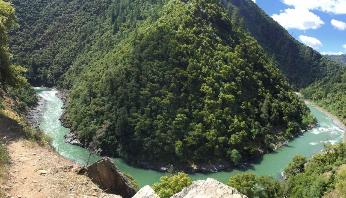
Mosquito Ridge Trail
This trail is very steep in places with many switchbacks, as it winds its way down to the Middle Fork of the American River.
This trail is very steep in places with many switchbacks, as it winds its way down to the Middle Fork of the American River. About halfway down across the canyon, there is a pretty cascade of water coming down the canyon wall. The river has good fishing at times, and there are adequate campsites on the large gravel bars along the river. Fire permits are required for campfires, backpacking stoves, BBQs and lanterns. Because this is a southerly exposure, the trail can be hot during a warm day, and is a pleasant hike during the spring and fall. Poison Oak is present, especially at the beginning of the trail.
- Distance 1 mile each way
- Difficulty Difficult
- Website Mosquito Ridge Trail
- Best Feature About halfway down across the canyon, there is a pretty cascade of water coming down the canyon wall
- Hiking
- Biking
- Equestrian

From Interstate 80, take the Foresthill exit to Foresthill Road and proceed 15.5 miles to the Foresthill Ranger Station. Continue 1.2 miles and turn right onto Mosquito Ridge Road. Travel approximately 12.4 miles to the trail sign on the right. Park on the left side of the road in the turnout and then cross the road to begin the trail.
ALSO CHECK OUT:
-
Lake Valley Reservoir
Donner Summit, CADonner Summit, CAPG & E Lake Valley Reservoir, 2 miles long, is located in a beautiful forested setting and offering some terrific Sierra outdoor recreation for all ages.
-

Burton Creek State Park
Tahoe City, CA2309 North Lake Boulevard, Tahoe City, CA 96145Six miles of unpaved roadway are available for hiking, mountain biking, and cross-country skiing.
-

Tahoe Adventure Company
Tahoe Vista, CA7010 North Lake Boulevard, Tahoe Vista, CA 96148The Tahoe Adventure Company leads high quality adventure travel trips and tours with a focus on experiencing the natural beauty of the surrounding mountains, trails and brilliant waters of Lake Tahoe.


