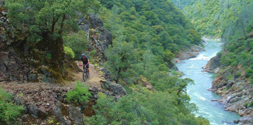
Green Valley Trail
From Interstate 80, take the Foresthill exit to Foresthill Road and proceed 15.5 miles to the Foresthill Ranger Station
From Interstate 80, take the Foresthill exit to Foresthill Road and proceed 15.5 miles to the Foresthill Ranger Station. Continue 10 more miles to Sugar Pine Road (Forest Road 10). Follow it for 5 miles until you cross Sugar Pine Dam. One mile beyond the dam, turn right on to Elliot Ranch Road, which is the dirt road just past the paved road to the campground. Travel 3 miles to the signed trailhead and make a left. NOTE: The road is rocky and a high clearance vehicle is advised.
- Distance 2.62 miles each way
- Difficulty Difficult
- Website Green Valley Trail
- Best Feature Good fishing is available at times, and river access with limited camping is possible along the trail
- Hiking
- Biking
- Fishing

From Interstate 80, take the Foresthill exit to Foresthill Road and proceed 15.5 miles to the Foresthill Ranger Station. continue 10 more miles to Sugar Pine Road (Forest Road 10). Follow it for 5 miles until you cross Sugar Pine Dam. One mile beyond the dam, turn right onto Elliot Ranch Road, which is the dirt road just past the paved road to the campground. Travel 3 miles to the signed trailhead and make a left. NOTE: The road is rocky and a high clearance vehicle is advised.
ALSO CHECK OUT:
-
The Wildest Ride
Auburn, CA1273 High Street, Auburn, CA 95603A bicycle race offering a variety of options for participants–from 40 miles to 140 miles.
-
North Fork Campground
Emigrant Gap, CATexas Hill Road, Emigrant Gap, CA 95715North Fork Campground is located near a beautiful creek in a remote location. It is shaded by cedar, pine, and fir trees and is a pleasant escape.
-

Woodcreek Golf Club FootGolf Course
Roseville, CA5880 Woodcreek Oaks Boulevard, Roseville, CA 95747FootGolf is a fun new game that combines the popular sports of soccer and golf. It is easy to learn and a great group activity for people of all ages.


