

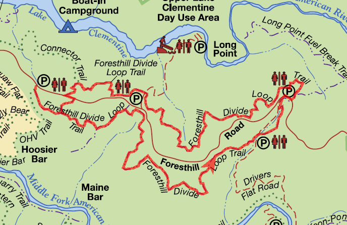
Foresthill Divide Loop Trail
This loop offers some beautiful views of Lake Clementine and both the North Fork and Middle Fork American Rivers.
This loop offers some beautiful views of Lake Clementine and both the North Fork and Middle Fork American Rivers. Straddling the Foresthill Divide at elevations ranging from 1600 to 1900 feet, it provides a diversity of flora as it passes through all four American River Canyon eco-systems: yellow pine forest, foothill woodland, riparian woodland, and chaparral. It also passes through open grasslands that are abundant with wildflowers in the spring.
- Distance Distance: 8.2 miles Shorter loops are also possible. Add 1 mile from Trailhead West.
- Approx length of time 4.1 hours (hiking)
- Difficulty Easy to Moderate
- Website Foresthill Divide Loop Trail
- Best Feature Passes by the old rock foundation of the Grizzly Bear House
- Hiking
- Biking
- Equestrian

Trailhead West is on Foresthill Rd, 3½ miles east of Foresthill Bridge, at a large parking area on the right (known locally as the Grizzly Bear House turnout).
Trailhead East is on Foresthill Rd, 7 miles east of Foresthill Bridge (0.2 miles past Drivers Flat Road) at a large parking area on the left. Both trailheads have a port-a-potty.
ALSO CHECK OUT:
-
Foresthill OHV Area
Foresthill, CAPlacer County, Foresthill, CAForesthill has an outstanding, nearly 100 mile OHV trail system suitable for both motorcycles and ATVs less than 50 inches in overall width.
-
Tahoe State Recreation Area & Campground
Tahoe City, CANorth Lake Boulevard, Tahoe City, CA 96145The campground has 23 campsites with picnic tables, required-use food storage containers, and fire pits.
-

Kings Beach Boat Launch Facility, Kings Beach Picnic Area and Dog Beach
Kings Beach, CACoon Street and Brockway, Kings Beach CA 96143Coon Street Picnic is the perfect spot for small picnics at its one acre shaded picnic area and rocky beach.


